
Major Coast-to-Coast Weather Hazards: California Flooding, Northeast Windstorm, and Heavy Mountain Snow
Dec 18, 2025
Stat 1: Up to 30” of precipitation has fallen in 2 weeks with the highest totals in the mountains east of Seattle. That's 30x the normal precipitation expected for this period of time.
Stat 2: Over the past 36 hours, 23 separate wind gusts of 100+ mph have been measured in the West.
High Impact Weather Events
FLOODING RAIN CONTINUES, BUT TARGETS CALIFORNIA THROUGH THE WEEKEND
Tropical moisture continues to funnel off the Pacific into the West Coast Friday through mid-next week. There will be a slight progression southward heading into the weekend, placing Northern California in the highest risk areas to flash flooding for each of the next four days, likely longer. Several storms will move into the west coast, targeting most of California Tuesday through Sunday of next week!
SHOT OF HEAVY RAIN AND GUSTY WINDS FOR NORTHEAST ON FRIDAY
A cross-country system pushes through the northeast overnight Thursday through Friday, sparking heavy rain and strong damaging wind gusts. NYC, Boston, Philadelphia may see damaging wind gusts on Friday. A low-end flooding threat is in place across portions of New England with heavy rainfall pairing with snow melt leading to excessive runoff.
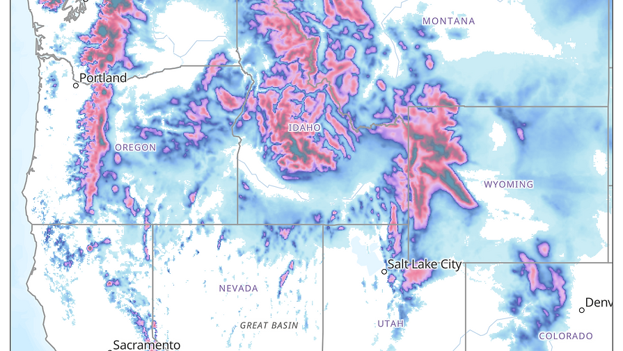
CONTINUED MOUNTAIN SNOW ACROSS THE CENTRAL AND NORTHERN ROCKIES THIS WEEKEND
As moisture continues to drift inland from the atmospheric river, widespread mountain snowfall will continue to fall through the weekend and well into next week. Multiple feet of snow could pile up at some of the highest peaks in Colorado, Wyoming, Idaho, Montana, and the Cascades.


THE ATMOSPHERIC RIVER FLOWS ON…
The situation doesn’t ease up this weekend. Constant moisture will support new rainfall Sunday & Monday. Sunday may be most concerning here with rain totals of 1 to 5 inches possible over saturated soils and varying terrain. This sets up the chance for multiple flooding instances across Sacramento, San Fran, and By Monday, the same area continues to see rounds of steady to heavy rain, but with less of a punch. Still, there should be a couple of instances of flash flooding across sections of Northern California with another 1-2 inches possible.


RAIN TOTALS & MORE TO COME
The rain totals across the West Coast through Monday are alarming. Widespread totals of 4 to 8" are likely between this posting through Monday evening.
And what’s worse? Several storms are expected to push into southern California Tuesday-Sunday of next week, spoiling some Christmas plans and bringing the risk for flooding back into the region.
The flood risk next week? The entire California coast.


FRIDAY RAIN AND WIND EVENT ACROSS NORTHEAST
One of the storms that fueled the atmospheric river across the West Coast earlier this week will push through the Northeast on Friday, packing heavy rain and damaging wind gusts.
In terms of rain, up to 1.5" is possible across the region. But it will be the heavy rain pairing with up to an inch of snow melt that can lead to isolated flooding instances around Boston, Worcester, Springfield, Mass., and then cities like Portland, Maine, and Concord and Manchester, NH.
Strong damaging wind gusts will extend across all of the Northeast, with gusts between 40 to 60 mph stretching form Boston to Washington D.C., including NYC and Philadelphia.
Wind alerts are in place across over a dozen states for Friday.


MOUNTAIN SNOW CONTINUES INTO NEXT WEEK
The energy from a continuous atmospheric river event continues to spill and spread through in northern and central Rocky Mountains.
Scattered pockets of up slope, mountain snowfall will continue to stretch from the cascades into the northern and central Rockies each day through at least Monday.
A variety of winter weather alerts will come and go each of the next four days, but some of the mountain passes will see multiple feet of snowfall during the stretch. This includes areas just west of Denver, just east and north of Salt Lake City, and throughout Wyoming, Idaho, and Montana.
SERVICES & WHY CHOOSE US:
A disaster can leave you reeling if you’re not prepared. Our restoration team is not only here to help you clean up, but we also offer pre-loss planning to help you prepare for a variety of potential disasters so that you can minimize business interruption and get back up and running as quickly as possible.
OUR SERVICES INCLUDE
-
Pre-Loss Planning
-
Water & Storm Restoration
-
Fire & Smoke Restoration
-
Reconstruction
-
Mold Remediation
-
Electronics & Equipment Restoration Content & Document Restoration
-
Ancillary Services
WHY CHOOSE SERVICEMASTER? WE ARE AN INDUSTRY LEADER IN RECOVERY MANAGEMENT.
-
True Full-Service Partner
-
Branded/Uniformed First Response
-
Unparalleled Resources & Reach-Back Capabilities
-
Advanced Weather Notification App
-
Equipment & Resource Staging
-
Post-Storm Damage Assessment
-
Large Loss Job Reporting
-
Centralized Management
LATEST UPDATES:
Before a Storm:
Create A Hurricane Procedure Playbook
How Property Managers Can Prepare for Hurricane Season
After a Storm:
Tips on Reopening Your Business After a Natural Disaster
Evacuating in the Face of a Hurricane
YOUR FIRST CALL
BEFORE, DURING AND
AFTER DISASTER
ServiceMaster is an industry leader when it comes to emergency restoration services. Our team of highly trained professionals provide 24/7 response for any residential, or commercial property disaster, from fires and floods to extreme weather events and beyond.
With our years of experience in the field combined with cutting-edge technology, we can restore your business or home quickly and efficiently so you can get back on track as soon as possible.

WHAT TO DO/TIPS:
TIP 1
Safety First: Prioritize personal safety and that of your family. Avoid flooded areas and downed power lines.
TIP 2
Document Damage: Take photos or videos of any damage to your property for insurance claims.
TIP 3
Secure Property: Cover broken windows, tarp roofs, and board up openings to prevent further damage.
TIP 4
Contact Insurance: Notify your insurance company as soon as possible to start the claims process.
TIP 5
Mitigate Mold: Dry out the affected areas within 24-48 hours to prevent mold growth.
TIP 6
Dispose of Debris: Remove debris safely to prevent accidents and further damage.

The SMR and Monarch Weather & Climate Intelligence partnership empowers us to leverage cutting-edge weather intelligence to enhance our disaster response efforts.